

📍 Guerrero, Mexico
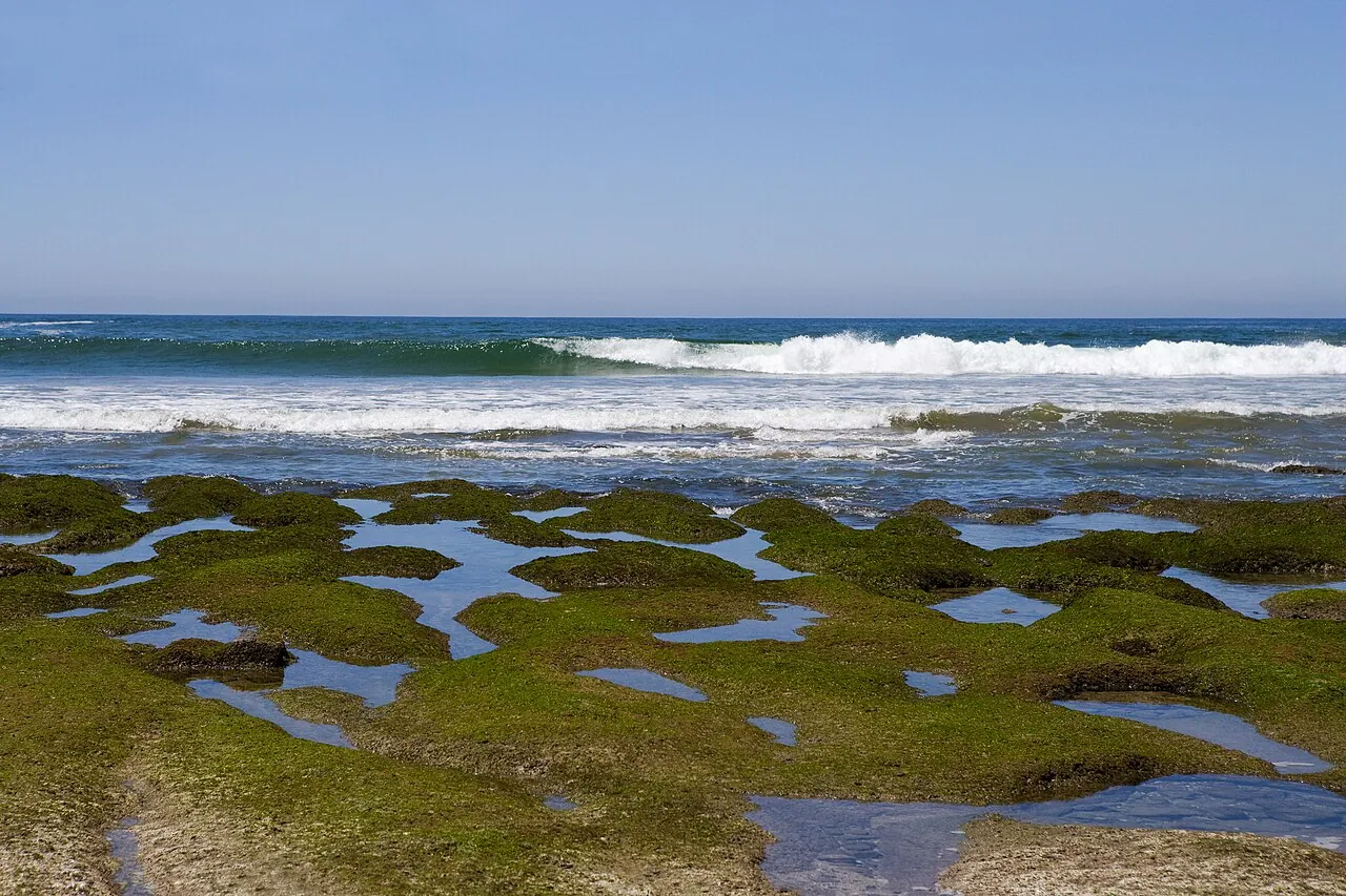
Photo: Ricardo Espinosa (reo) / CPTM, shared by Comisión Mexicana de Filmaciones / Wikimedia Commons, CC BY-SA 2.0
Troncones and La Saladita, on Guerrero's Costa Grande north of Zihuatanejo, are among the most written-about waves on Mexico's Pacific coast. Troncones offers a reef point and open beach breaks, and La Saladita has a long, slow left that longboarders travel for. The surf is real and well documented, and this page covers it.
The US State Department lists the whole state of Guerrero at Level 4, "Do Not Travel." That is the highest level it uses, and it covers Troncones and La Saladita as much as anywhere else in the state. This page describes what's there; it is not a recommendation to go. Read the advisory section before you read anything else, and check the live advisory yourself before you book.
United States. As of our check in September 2026, the State Department's Mexico advisory lists Guerrero at Level 4: Do Not Travel. Its restrictions on US government employees cover every part of the state, and they name Zihuatanejo and Ixtapa explicitly, so the tourist towns are not an exception. The same advisory tells US citizens to follow the restrictions that apply to government employees, which include not traveling between cities after dark. Advisories are reissued without notice, so rather than quote wording that may have changed by the time you read this, we're pointing you to the source: read the current Mexico advisory on travel.state.gov, including the Guerrero entry, before booking and again shortly before you travel.
United Kingdom and Canada. Both governments advise against all but essential (UK) or non-essential (Canada) travel to Guerrero, but they make a narrow exception for the town of Ixtapa/Zihuatanejo, when reached by air. The UK's FCDO also warns that crime groups run illegal roadblocks in the state and advises against driving after dark.
What that means for a surf trip. Troncones and La Saladita are not in Ixtapa or Zihuatanejo; you reach them by road from the airport. So even the UK and Canadian carve-out, which the US advisory doesn't have at all, does not cover them. That's our reading of the published wording, not an official interpretation. If you're weighing a trip anyway, also check whether your travel insurance covers a destination under a Level 4 advisory rather than assuming it does.
We're not going to tell you the risk is overstated, and we haven't gone looking for reasons it might be. If you'd rather surf a Mexican Pacific coast the State Department doesn't list at Level 4, this site's Oaxaca and Baja California Sur guides are the places to start.
Troncones, La Saladita and the Ixtapa-Zihuatanejo beaches are all within about an hour's drive of one airport and suit different surfers.
A left-hand reef point for experienced surfers and sandy beach breaks along the town's shoreline that are friendlier when the swell is small.
Troncones in detail arrow_forward
A long, slow, peeling left over rock, cobble and sand, known above all as a longboard wave, a short drive up the coast from Troncones.
La Saladita in detail arrow_forwardPlaya Linda's beach break and a few smaller, more conditional spots near the resort towns and the airport.
Ixtapa-Zihuatanejo in detail arrow_forwardThe short version, with the advisory first because it matters most.
Troncones Point, at the Manzanillo Bay end of town, is the wave most people mean when they talk about surfing Troncones. It's a left that wraps over rock and volcanic reef, with a steep, shallow takeoff at low tide, and local surf shops and travel accounts rate it intermediate to advanced. Tsunami Surf, a local shop, warns on its own site that the reef is full of sea urchins and that bigger swells bring strong rip currents. Booties and a healthy respect for the tide are worth bringing.
The beach break follows the town's sandy shoreline with shifting peaks and both lefts and rights; it's the more approachable option when the swell is small and usually best in the morning before the wind picks up. Near the river mouth the sandbars can make it heavier. Playa Majahua is described by one surf guide as a gentle beach break for beginners to intermediates; we couldn't find a source that says which way it usually breaks.
See Troncones on Google Maps open_in_newThe Ranch gets its own Surfline forecast in the Troncones area, and surf guides describe it as a reef break for experienced surfers. They disagree on where exactly it sits relative to town, so we're not giving a distance; ask a local shop.
Schools and rentals. Tsunami Surf (board rentals, lessons, guiding and boat trips to other breaks) and Troncones Tours / Capitán Mantarraya Surf Shop (lessons, rentals and surf tours from a shop in the center of town) both list their services on their own current websites. The Inn at Manzanillo Bay is listed by surf-camp directories with an on-site board rental center; we found that in listings, not on a page of its own. Confirm opening dates directly before you plan around any of them.
La Saladita sits north-west of Troncones in the same municipality, La Unión de Isidoro Montes de Oca. One local guide puts it about 15 km (9 miles) up Highway 200 from the village, roughly a 15-minute drive. It's a long, slow, peeling left-hand point break, and local guides nickname it the "wave machine." Guides describe the bottom variously as reef, cobblestone, or boulders and sand; what they agree on is that it isn't pure sand, which is why some surfers wear booties. They also consistently describe it as longboard-friendly and forgiving when small, which is why it draws a crowd.
"Forgiving" is relative. A recent surf guide reports exposed rock at the point, sea urchins that are worst at low tide, and a current that runs down the point and can push newer surfers toward the rocks. The same guide says there are no lifeguards. Bigger south swells make it a more serious wave, and crowding is the other hazard guides mention most.
See La Saladita on Google Maps open_in_newSaladita Surf School runs beginner and intermediate lessons at the beach and has a current website of its own. Surf guides dated 2026 name board rentals at the point (Brandon Surf, Dr. Salty and Marea restaurant among them), but we found those in guides rather than on the businesses' own pages, so treat them as leads to check. One of those guides says La Saladita has no dedicated surf camp at the moment.
Playa Linda, the long beach north of Ixtapa's hotel zone, is the resort area's main surf beach. It's a beach break, best near the river mouth, and surf guides describe it as suiting beginners through intermediates depending on size. The same estuary is crocodile habitat: local guides warn that crocodiles move between the lagoon and the sea there, so stay clear of the river mouth and follow any signs.
Surfline's regional listings include Playa Las Gatas in Zihuatanejo bay and Barra de Potosí to the south, but guides describe them as sheltered or inconsistent rather than reliable surf. El Palmar, in front of the Ixtapa hotels, is described by a regional tourism guide as having small, consistent waves for beginners; we didn't find it in specialist surf databases.
Remember that the UK and Canadian exception for "Ixtapa/Zihuatanejo accessed by air" covers the town, not the wider coast. The US advisory makes no exception for either town. See the advisory section.
Petacalco is in Guerrero, in La Unión municipality, near the mouth of the Río Balsas and the Michoacán state line. Surf sources describe a heavier beach break shaped by the river mouth, but we couldn't find a reliable account of its bottom or a firm skill rating, so we're not giving one. It sits right by Michoacán, which the State Department also lists at Level 4.
Pascuales is a heavy beach break often listed with Mexican Pacific trip plans, but it is not in Guerrero. It's in the state of Colima, near Tecomán, a different state with its own advisory entry.
Summer is the swell season. Surf guides converge on south and south-west groundswell from roughly April/May through October, with the most consistent, biggest surf in May through September. Surfline's own Troncones guide frames the best season more broadly as March to October. Winter (November-February) is generally smaller and cleaner, with some north-west swell and lighter winds, and it's the easier time for beginners and longboarders. All of this comes from surf guides and forecast sites, not from a government wave record, which doesn't exist for this coast.
The water is warm all year. SeaTemperature.org's monthly averages for Zihuatanejo run from about 79°F (26°C) in March, the coolest month, to about 86°F (30°C) in July and August. That's boardshorts or bikini water; a rash guard or a thin top is for sun and reef, not warmth. Our wetsuit thickness guide has the full temperature bands.
Hurricanes overlap the surf season. The US National Hurricane Center's eastern Pacific season runs from May 15 to November 30, which covers the whole south-swell window. Canada's travel advice also lists Guerrero among the Mexican states where earthquakes occur and notes tsunami risk on the coast; know the evacuation routes wherever you stay.
Ixtapa-Zihuatanejo International Airport (ZIH) is the gateway for this whole stretch. Nonstop service from US cities exists, but routes and seasons change, so check current schedules for your dates rather than relying on a list here. From ZIH, Troncones is roughly 30-40 minutes by road and La Saladita roughly 40-60 minutes, per travel guides. Troncones is about 20 miles (32 km) north-west of Zihuatanejo.
For the passport and FMM tourist-permit rules that apply to any US citizen entering Mexico, see our Mexico country guide. Keep in mind that the drive from the airport to either beach is road travel, which is outside the UK and Canadian "by air" exception, and that the US advisory tells citizens not to travel between cities after dark.
Guerrero is in Mexico, so US Coast Guard rules don't apply here, and neither does any European rule this site covers elsewhere. Mexico's maritime authority is SEMAR (Secretaría de Marina), working locally through the Capitanía de Puerto de Zihuatanejo. Its jurisdiction, per SEMAR and federal documents, covers the coastline of La Unión de Isidoro Montes de Oca (Troncones, La Saladita, Petacalco), José Azueta (Ixtapa-Zihuatanejo) and Petatlán.
We found no federal, state or municipal rule requiring surfers to wear a life jacket, and no published ordinance that sets surf zones on these beaches. That's reported as "not found," not as "confirmed exempt." We also found no official document describing lifeguard coverage or a flag system here; travel sources say some main resort beaches have lifeguards and flags, and a surf guide says La Saladita has none. Treat any flags or instructions on the beach as the ones to follow.
In an emergency, dial 911, Mexico's national emergency number.
What surfers most often ask about Troncones and La Saladita.
The US State Department lists all of Guerrero, including Troncones, at Level 4: Do Not Travel and tells US citizens to follow the same restrictions as government employees, who may not travel anywhere in the state. The UK and Canada make an exception only for Ixtapa/Zihuatanejo reached by air, which doesn't include Troncones. Read the current advisory on travel.state.gov before deciding; we can't make that call for you. In the water, the main hazards are the reef and urchins at the point and rip currents when the swell is big.
La Saladita, on a small day. Its long, slow left is known as a longboard and learner-friendly wave, though the current down the point and the rocks at low tide still catch people out. At Troncones, the beach break is the beginner option when it's small; the point is for intermediate and advanced surfers.
For consistent swell, May through September, inside a wider south-swell season of roughly April/May to October. Winter is smaller and cleaner, which suits beginners and longboarders. The surf season overlaps the eastern Pacific hurricane season, May 15 to November 30.
Warm all year, from about 79°F (26°C) in March to about 86°F (30°C) in July and August, based on SeaTemperature.org's monthly averages for Zihuatanejo. No wetsuit needed.
Ixtapa-Zihuatanejo International Airport (ZIH) is roughly 30-40 minutes by road from Troncones and roughly 40-60 minutes from La Saladita, per travel guides.
No. Pascuales is in the state of Colima, near Tecomán. Petacalco, near the Michoacán state line, is Guerrero's northernmost documented surf spot on this page.