

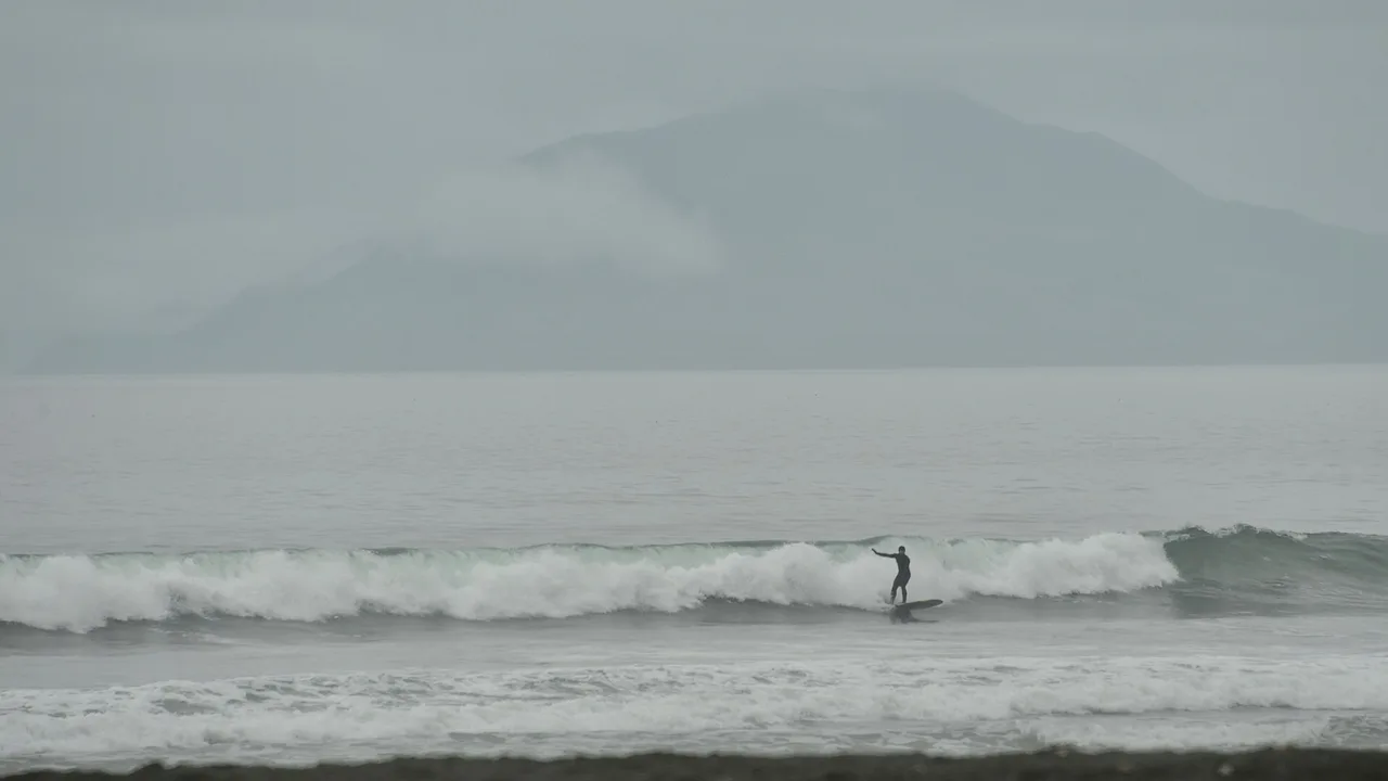
📍 Alaska, United States
Photo: James Brooks / Wikimedia Commons, CC BY 2.0 — Surfers' Beach, Kodiak, July 2021.
The Gulf of Alaska sits under the North Pacific storm track. The waves are real; getting to them is the hard part.
Alaska's surf coast faces the Gulf of Alaska, and the offshore buoy we use averages 10-11 feet of wave height through the winter. The three places with a documented, local surf scene are Yakutat, Sitka and Kodiak. None of them is on Alaska's road system: you fly in, or you take the state ferry, and then you drive the few local roads that exist. Beyond those roads, the best-known waves are reached by boat or small plane.
The one exception is near Anchorage. The Turnagain Arm bore tide runs right alongside the Seward Highway, and it gets more searches than Alaska surfing itself. It is a tidal wave in a glacial-silt inlet, not ocean surf, and it needs to be treated as its own, separate thing.
Southeast Alaska's two surf towns: Yakutat's long beaches on the "Far North Shore," and Sitka's in-town break plus boat-access reef on Kruzof Island.
Yakutat & Sitka arrow_forward
Two beach breaks you can actually drive to, about an hour out of town, on a road a rocket spaceport sometimes closes.
Kodiak arrow_forward
A tidal bore up to 6 feet high, according to NOAA, running at 10-15 mph past the Seward Highway. Spectacular, and not a beginner's wave.
The bore tide arrow_forwardFive years of NOAA hourly data (2021-2025) from one offshore buoy and two harbor gauges.
NDBC 46084 is 25 nautical miles south-southwest of Cape Edgecumbe, off Sitka, in the open Gulf of Alaska. It measures swell and water temperature out at sea, so its wave heights are open-ocean significant heights, not the size of the wave at any beach. YATA2 (Yakutat Bay) and KDAA2 (Kodiak Island) are NOAA tide gauges that record water temperature close to town. The Kodiak gauge has no 2025 file yet, so its column covers 2021-2024.
| Month | Water (46084, off Sitka) | Water (Yakutat) | Water (Kodiak) | Wave height (46084) | Dominant period |
|---|---|---|---|---|---|
| January | 45 °F / 7.1 °C | 42 °F / 5.3 °C | 38 °F / 3.1 °C | 10.9 ft / 3.3 m | 12.0 s |
| February | 43 °F / 6.3 °C | 40 °F / 4.5 °C | 37 °F / 3.0 °C | 10.1 ft / 3.1 m | 11.4 s |
| March | 43 °F / 6.2 °C | 40 °F / 4.7 °C | 37 °F / 2.7 °C | 8.9 ft / 2.7 m | 10.6 s |
| April | 44 °F / 6.8 °C | 43 °F / 5.9 °C | 40 °F / 4.3 °C | 7.8 ft / 2.4 m | 10.1 s |
| May | 47 °F / 8.3 °C | 47 °F / 8.2 °C | 43 °F / 6.4 °C | 6.3 ft / 1.9 m | 9.9 s |
| June | 51 °F / 10.7 °C | 52 °F / 10.9 °C | 47 °F / 8.5 °C | 5.2 ft / 1.6 m | 10.4 s |
| July | 56 °F / 13.3 °C | 54 °F / 12.5 °C | 50 °F / 10.1 °C | 4.1 ft / 1.3 m | 10.1 s |
| August | 58 °F / 14.5 °C | 56 °F / 13.6 °C | 53 °F / 11.6 °C | 5.0 ft / 1.5 m | 9.8 s |
| September | 56 °F / 13.3 °C | 54 °F / 12.3 °C | 51 °F / 10.8 °C | 8.0 ft / 2.5 m | 10.0 s |
| October | 52 °F / 11.2 °C | 51 °F / 10.6 °C | 47 °F / 8.3 °C | 9.8 ft / 3.0 m | 10.5 s |
| November | 48 °F / 9.1 °C | 47 °F / 8.3 °C | 41 °F / 5.0 °C | 10.6 ft / 3.2 m | 11.1 s |
| December | 45 °F / 7.5 °C | 43 °F / 6.2 °C | 37 °F / 2.5 °C | 11.0 ft / 3.4 m | 11.2 s |
This is a long-period groundswell coast in every month. The dominant period at 46084 never averages below 9.8 seconds and runs 11-12 seconds from November through February, when the average open-ocean wave height is around 10-11 feet. Summer is the small season: July averages 4.1 feet at the buoy. That is why the one boat-trip operator we found schedules its main trips for spring and fall rather than midwinter, when the swell is biggest but the storms and the short days get in the way.
The water never gets warm. The best month anywhere in the table is August at the offshore buoy, 58 °F. In Kodiak's harbor it drops to 37 °F from February through March and again in December. Alaska Surf Guides, the Seward operator, gives South Central Alaska's range as 39-56 °F and rents 5/4 mm hooded suits with boots and gloves; a Kodiak surfer's own guide describes a 5/4 with hood, gloves and booties most of the year and a 6/5 in the dead of winter. Our wetsuit thickness guide turns these temperatures into a suit recommendation. For most of the year, expect to need the thickest suit it suggests.
Both towns are fly-in or ferry-in only. Each has one easy wave near town and better waves farther out.
Yakutat is the town most associated with Alaska surfing ("yakutat surfing" alone draws about 210 US searches a month). The local chamber of commerce says the town "has become known for extreme surfing in both winter and summer," and names Icy Waves as the local surf shop renting gear. Cannon Beach, the best-known break, is a long, open ocean beach named for the World War II cannons that still stand there. The chamber pages that describe all this date from around 2010, and we could not confirm the shop's current hours or whether it still rents boards, so call ahead before you count on renting a board there. Bears, the chamber adds, "may be seen almost anywhere in the Yakutat area," including along the shorelines.
Getting there: Yakutat has no road connection to the rest of Alaska. Alaska Airlines flies there; check the current schedule rather than assuming daily service. The Alaska Marine Highway ferry has historically called at Yakutat on cross-Gulf sailings, but its route page says the proposed winter 2026/27 schedule will not travel to Yakutat or run cross-Gulf routes at all.
Sitka is on Baranof Island, facing the open Gulf. Sandy Beach is the in-town, road-access break but needs a sizable outer-coast swell to work. According to local surfers interviewed by Sitka public radio in 2016, the better waves are reached by boat on Kruzof Island, about 10 miles west, where old lava flows from Mount Edgecumbe form the reef. Sitka's former surf shop, Cold Salt, is reported closed, and we found no current replacement. Bring your own board, or plan around a boat operator.
Getting there: Alaska Airlines serves Sitka, and the Alaska Marine Highway ferry also calls there; the ferry's sample running time from Juneau is 9 hours 30 minutes.
The one place on this page where you can check the surf from a car.
Kodiak's surfing happens around Pasagshak, at the end of the road network south of the city. A local surfer's own guide names two main spots: Surfers' Beach (also called Three Mile Beach), a beach break with a noticeable cross-current, about 1 hour 10 minutes from town, and Fossil Beach, which the same writer rates as the best accessible wave, about 1 hour 20 minutes out. When Surfers' Beach is big and messy, that guide says, the mouth of the Pasagshak River at Pasagshak State Recreation Site can offer a cleaner right. We found no surf shop or board rental in Kodiak.
The road can close. The road to both beaches passes the Pacific Spaceport Complex-Alaska at Narrow Cape. In August 2025, Kodiak public radio (KMXT) reported that it was being closed from 5 p.m. to 1 a.m. on several nights for "hazardous operations," at a point just past the boat ramp near Pasagshak State Recreation Site. That blocks access to Surfers' Beach as well as Fossil Beach. Check for spaceport closure notices before you make the drive.
Getting there: Kodiak is an island with no road link to the mainland. You can fly in, or take the Alaska Marine Highway ferry, which serves Kodiak year-round. Its sample running time from Homer is 9 hours. Kodiak's water is the coldest in our table, 37-38 °F from December through March at the harbor gauge.
A roadside wave near Anchorage. It is also the most dangerous water on this page.
Cook Inlet's tides are among the largest in North America, and Turnagain Arm is narrow, shallow and gently sloping. Together they push the incoming tide up the Arm as a single breaking front. NOAA's own guide to it, Alaska Bore Tales (first written in 1985, last revised in April 2007), gives the essentials: in Turnagain Arm, "bores range in size from 1/2 foot to 6 feet high and travel at speeds between 10 and 15 mph." The bore forms at the mouth of the Arm within an hour of each predicted low tide at Anchorage and takes about 5 1/2 hours to reach the head. The most dramatic bores come with extreme minus tides, between -2.0 and -5.5 feet, around the new and full moon.
Timing it: NOAA's guide suggests watching between McHugh Creek and Indian Creek, or from the Hope campground on the south shore, and says the bore reaches the Indian Creek pullout on the Seward Highway about 1 1/2 hours after Anchorage low tide. The Arm's channels shift constantly, so treat any published arrival time, ours included, as an estimate.
Riding it: surfers and paddleboarders have been reported riding the bore, but we could not pin down a reliable account of how far a ride can go; we therefore don't quote one. The same NOAA guide recounts an Alaska State Parks ranger who had seen "windsurfers barely escape the bore at Beluga Point," and it is blunt: "The best advice is not to be in the water or near the shore shortly after low tide, especially during an extremely low tide." We found no specific rule that bans riding the bore, and no official guidance written for surfers on it. That is not the same as permission. The water is cold and silty, the current is fast, and the tidal flats in the Arm are soft glacial mud that has trapped people as the tide came in, in some cases fatally.
Where most visiting surfers actually find Alaska's waves.
Alaska Surf Guides runs surf trips from Seward aboard the 48-foot M/V Aleutia. Its website lists 7-day trips in spring (March to May) and fall (August to October), with shorter summer charters from mid-May through June. The US Coast Guard limits it to 6 passengers as an uninspected passenger vessel, and it rents boards and cold-water wetsuits. Its 2026 fall and 2027 calendar was live when we checked.
Seward is the harbor these trips leave from, not a surf spot in its own right; we found no documented break inside Resurrection Bay, and none at Homer or in Kachemak Bay either.
Very little is documented. Kite and windsurf searches for Alaska barely register: 10 a month or fewer for every term we measured. We found no kiteboarding school, no club and no named, regularly used spot anywhere in the state. The only primary mention of windsurfing we found is the Beluga Point near-miss in NOAA's bore-tide guide. The offshore buoy is windy (at 46084, winds reach 15 knots or more in about half the hours from October through December), but a buoy 25 nautical miles offshore says nothing about conditions at a beach launch. Treat Alaska as a surf destination, and ask locally if you want to fly a kite.
A surfboard ridden inside the surf zone is not a vessel under federal law. A stand-up paddleboard becomes one once it is used beyond the limits of a swimming, surfing or bathing area. From that point, 33 CFR 175.15 requires a USCG-approved wearable life jacket on board for each person, and 33 CFR 175.19 requires it to be readily accessible; Coast Guard guidance also expects a sound-signaling device such as a whistle, and a light after sunset. Federal law does not require adults to wear the life jacket; its wear rule covers children under 13 on a boat that is under way. Alaska doesn't either: the state Office of Boating Safety's requirements card says only that anyone under 13 must wear a life jacket in an open boat, on the deck of a boat, or when being towed. We found no Alaska rule written for surfboards, and no Alaska ruling on whether that under-13 rule covers a paddleboard. The federal baseline for the whole country is set out on our United States guide.
Emergencies: 911, or the Coast Guard on VHF 16. Alaska's waters are covered by the Coast Guard's Arctic District, based in Juneau, which was called District 17 until it was renamed in July 2025. Rescue here can mean a long wait: the breaks on this page are remote, and some are only reached by boat or plane.
Every monthly average in our table is below 60 °F, and in winter the harbor gauges read below 45 °F. The National Weather Service warns that cold shock can cause a sudden gasp and rapid breathing in the first few minutes of immersion, even for strong swimmers. Surf with someone else and tell someone ashore where you've gone. Bears are part of the shoreline here; Yakutat's chamber of commerce says they may be seen almost anywhere around town, and a Kodiak surfer's guide mentions bears on shore. Keep your distance, and don't leave fish or food at the car. Yakutat, Sitka and Kodiak are all coastal towns in an earthquake zone. The National Weather Service's advice is that if you are on the beach and feel an earthquake, whatever its size or length, you should move off the beach to high ground or inland as soon as you safely can.
Yes. Yakutat, Sitka and Kodiak all have documented local surf scenes, and the Gulf of Alaska produces long-period groundswell in every month; the dominant period at NOAA buoy 46084 averages 9.8 to 12 seconds. The crowds are tiny. The obstacles are access, cold water and weather.
The buoy data puts the biggest swell in November through February, around 10-11 feet of open-ocean wave height off Sitka, and the smallest in July, at about 4 feet. The Seward boat-trip operator runs its main trips in spring (March to May) and fall (August to October), a compromise between swell, storms and daylight.
From 37 °F in Kodiak's harbor in winter to 58 °F at the offshore buoy off Sitka in August, on five years of NOAA data. Local operators and surfers describe 5/4 mm hooded suits with boots and gloves as the norm; see our wetsuit thickness guide for what the numbers mean for your suit.
People have been reported riding it, and we found no specific rule banning it, but NOAA's own guide advises staying out of the water and away from the shore shortly after low tide. The bore can reach 6 feet and travels at 10-15 mph over cold, silty water and soft mudflats. It is not ocean surf, and it is not a place to learn.
Yakutat, Sitka and Kodiak lack road links to the rest of Alaska, so you arrive by plane or state ferry. Kodiak's two main beaches lie about an hour's drive from town, while Sitka's Sandy Beach sits on the local road. The Turnagain Arm bore tide is the only wave on this page you can drive to from Anchorage.