
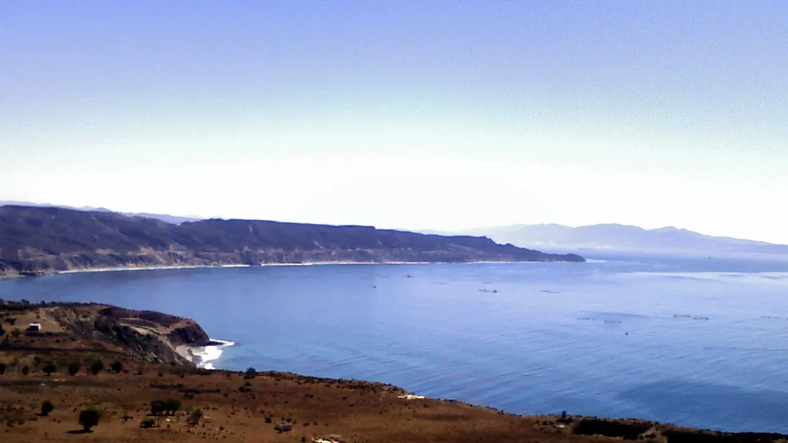
Photo: Gabriel Flores Romero / Wikimedia Commons, CC BY 2.0
This is the northern Mexican state — Tijuana, Rosarito, Ensenada — not Baja California Sur (La Ventana, Los Cabos), a different state roughly 700 miles further south down the same peninsula. It's a genuinely different place with a genuinely different scene: this coast is Southern California's own backyard surf trip, not a Sea of Cortez kite destination. If you're looking for La Ventana's winter wind season, that's a different state.
The Pacific coast between Tijuana and Ensenada packs in two of Baja's best-known reef points — K38 and Salsipuedes — plus Isla Todos Santos, a boat-only big-wave venue that surfers compare to Mavericks. All three are reachable on a day trip from San Diego, which is exactly why generations of Southern California surfers have made the drive.
Everything on this page sits within about an hour and a half of the border, off the same coastal highway.
Two reef/point breaks near Rosarito — one a reliable intermediate right, the other a heavier, more advanced wave.
The reef points arrow_forward
A boat-only big-wave break off Ensenada, inside a federally protected island reserve.
Killers, in detail arrow_forward
The border, the toll road, Mexican insurance, and what the US State Department actually says about this stretch.
Crossing the border arrow_forwardBoth named for their position on the old federal highway — a Baja naming convention worth knowing before you go looking for either on a map.
K38 (Kilometer 38) takes its name from its position on the Tijuana-Ensenada road. Surf-travel and forecast sites consistently describe it as a right-hand point breaking over a rocky, cobblestone-style reef, working best on northwest to west swells (some sources also note it can pick up south swells), and generally rated intermediate — one of the first "real" Baja waves most Southern California surfers ride, long and forgiving rather than heavy. Booties are commonly recommended for the rocks underfoot.
Salsipuedes, a few kilometers further south, is described the same way in kind but not in degree: a heavier right-hand point and reef that needs a bigger west-northwest or south swell to turn on, and is rated advanced rather than intermediate. It's a step up from K38, not a beginner alternative to it.
| Spot | Break type | Best swell | Level |
|---|---|---|---|
| K38 | Right point, rocky/cobblestone reef | NW-W (some S) | Intermediate |
| Salsipuedes | Right point, reef (heavier) | Big NW-W or S | Advanced |
All of this comes from surf-forecast and surf-travel sites (Surfline, Surfnerd, San Diego Magazine, Rosarito Resorts, MexBound) rather than any government survey — there is no official Mexican wave-height or bathymetric record for either spot, and none was expected to exist. Treat the swell-direction and level guidance above as informed surf-community consensus, not measured fact.
A genuine big-wave venue, not a marketing exaggeration — but every size figure below is a surf-industry estimate, not a government measurement.
Isla Todos Santos sits about 12 miles (19.3 km) off Ensenada, and the wave known as "Killers" breaks on an outer reef there — a genuine big-wave spot in the same category as Mavericks or Jaws, if not their equal in name recognition. Access is boat-only: charters run from Ensenada and from La Bufadora, a smaller access point south of the city. There is no bridge, no ferry service and no way to walk or paddle out from shore — you book a boat, or you don't go.
The season is winter, driven by the same North Pacific groundswell that lights up the whole California and Baja coast. Surf-forecast modelling tools put the spot's working range at roughly 15 to 60 feet of face height, and commercial big-wave reporting describes documented sessions with 30-foot-plus faces and contest days with 60-foot-plus faces. None of that is a measured government or scientific record — it's the surf industry's own forecasting and contest reporting, and we're stating it as such rather than as verified fact. What is consistent across every source: this is not a wave for anyone who isn't already comfortable in serious, heavy surf, and a boat, a tow-in setup or at minimum a strong paddle-out crew is the normal way people actually surf it.
The island sits inside a real federal protected area. Isla Todos Santos falls within the Reserva de la Biosfera "Islas del Pacífico de la Península de Baja California," declared by presidential decree published in the Diario Oficial de la Federación on 7 December 2016 and administered by CONANP (Comisión Nacional de Áreas Naturales Protegidas) — 21 islands and 97 islets along Baja's Pacific coast, of which the Todos Santos group is one. We could not obtain the decree's own island-by-island annex or the reserve's Programa de Manejo directly, so we are not quoting a specific surf, kite or boat-anchoring rule for Todos Santos by name — we simply did not find one, in either direction. If you're chartering a boat there, ask the operator directly what the reserve does and doesn't allow; don't assume either "no rules" or "surfing is banned."
We also could not find any documented charter-boat pricing, licensing or scheduling information from an official source — only general mentions from surf-travel operators that "multiple charter boats" run trips out of Ensenada. Book through an established local operator and confirm current conditions and any reserve-related paperwork before you go, rather than relying on this page for logistics that change season to season.
This is not a kite or windsurf destination, and the search data agrees: every kite and wind search term we measured for this coast came back at effectively zero volume, against real, if modest, numbers for surfing K38, Salsipuedes and Rosarito. Baja California's own official tourism page for Playas de Rosarito (bajacalifornia.travel) promotes surfing exclusively, with no mention of kite or wind sports at all.
Two things do turn up in commercial spot guides, for completeness. A kitesurf spot listing places a minor kite/windsurf spot at Rosarito itself, citing steady northwest wind suited to intermediate riders — no named school or rental operator was found to go with it. Separately, Punta San Carlos, a remote point roughly 80 km south of El Rosario (still within Baja California state, well south of Ensenada), is a long-documented wave-sailing destination among windsurfers and, more recently, kiters — cross-shore northwest wind onto a south-facing bay, reached via a dirt track off the main highway. Neither is confirmed by an official source, and neither changes what this coast is actually known for: if you're coming to Baja California for wind sports rather than surf, this isn't the state's showcase for it.
As with our Baja California Sur coverage, Mexico's federal maritime authority is SEMAR (Secretaría de Marina), exercised locally through the Capitanía de Puerto at Ensenada, under the Ley de Navegación y Comercio Marítimos. We found no federal or state PFD-wear mandate for surfers, kiteboarders, windsurfers or SUP riders who are not aboard a registered vessel — the same documented gap as Baja California Sur and several US states on this site.
We looked specifically for a Rosarito or Ensenada municipal ordinance naming surfing, kitesurfing or watersports at K38, Salsipuedes, or on this coast generally — the same search this site ran for Conil de la Frontera, Motril and Isla Canela on the Spanish coast, all of which turned up real, dated local rules. We found none here. That is reported as an absence found, not as proof no such rule exists — but it means there is no equivalent of a Spanish town's kitesurf ordinance to cite for this stretch of Baja.
Emergencies: 911, unified nationally in Mexico since 2017. At sea, VHF channel 16 is the international distress convention, though we did not confirm a Baja-specific SEMAR search-and-rescue channel beyond that convention.
Ensenada is roughly 70-75 miles (110-120 km) south of San Diego, a drive commonly quoted at around 1.5-2 hours depending on the border wait, mostly along the toll road (Mexico 1D, the "scenic highway") that runs from Tijuana through Rosarito to Ensenada, passing close to both K38 and Salsipuedes. A real cash or prepaid toll applies on 1D; a slower free road (the "libre") runs roughly parallel for drivers who'd rather skip it.
Check the current US State Department advisory before you go. As of the most recent update we could confirm, travel.state.gov places the entire state of Baja California — including Tijuana, Rosarito and Ensenada — at Level 3, "Reconsider Travel," citing terrorism, crime and kidnapping. The advisory is explicit that this does not add any extra restriction specific to Tijuana, Ensenada or Rosarito, or to the 1D toll road itself, beyond the general Level 3 guidance — and that the only area under additional restriction for US government employees is the Mexicali Valley, well inland and east of the spots on this page. Read the current advisory yourself before booking; it is updated periodically and this page is not.
US citizens need a valid passport (book or card) to re-enter the United States by land from Mexico — a standard, long-standing requirement, not something specific to this trip. Mexican auto insurance is widely recommended by insurance providers and travel guides for anyone driving a US-registered vehicle into Baja, on the reasoning that a typical US policy's liability coverage isn't recognized in Mexico — we found this stated consistently by commercial insurance and travel sources, but did not verify it against the specific Mexican statute or article number, so we're presenting it as strong practical advice rather than quoted law.
If you're bringing a board, note that Baja California is genuinely a different country with its own customs process — pack the ordinary paperwork (passport, vehicle permit if you're going beyond the border zone, proof of Mexican insurance) rather than assuming a day trip needs none of it.
What riders ask most before heading to Baja California.
No — Baja California and Baja California Sur are two different Mexican states on the same peninsula, roughly 700 miles apart. This page covers the northern state (Tijuana, Rosarito, Ensenada, K38, Salsipuedes, Isla Todos Santos). Baja California Sur (La Ventana, Los Cabos) is a separate page.
Yes. "Killers" is a boat-only big-wave break about 12 miles off Ensenada, with no bridge, ferry or shore access. Charters run from Ensenada and from La Bufadora; book through an established local operator and confirm current conditions before you go.
Not for a first-ever surf, but it's one of the more approachable Baja waves — surf guides consistently rate it intermediate, a long, forgiving right point rather than a heavy one. Salsipuedes nearby is a genuine step up, rated advanced.
Not really as a destination. Search demand for kite and wind terms on this coast is close to zero, and Baja California's own tourism page for Rosarito promotes surfing only. A minor commercial kite listing exists for Rosarito itself, and Punta San Carlos further south is a known wave-sailing spot, but neither makes this coast a wind destination the way Baja California Sur's Sea of Cortez side is.
Check the current US State Department advisory before you go — as of our last check it places the whole state of Baja California at Level 3, "Reconsider Travel," for terrorism, crime and kidnapping, while explicitly not adding extra restrictions specific to Tijuana, Rosarito, Ensenada or the 1D toll road. Read the live advisory yourself rather than relying on this page, which isn't updated in real time.
None that we could find. We looked specifically for a Rosarito or Ensenada municipal ordinance naming surfing, kitesurfing or watersports at these spots, the way several Spanish coastal towns have documented kitesurf ordinances, and found nothing equivalent here. That's an absence found, not proof no rule exists.
In an emergency call 911.